The main national RN8 road is not a great solution for driving from Fez to Marrakech as it's a busy single lane route almost all the way and not at all conducive to a relaxing time. I always recommend getting off the RN (national) routes and instead travel on RR (regional) and RP (provincial) routes instead where possible.
This is a two day route plan through the Middle Atlas that on the first day incorporates lakes, karst scenery, 'little Switzerland', volcanos, wild monkeys, cedar forest and a massive river formation, finishing at Khenifra. The altitude varies between the 400m of Fez reaching 1750m at Ifrane and ending at 1000m in Khenifra. Despite being a route through the mountains the Middle Atlas is very much a plateau highland with no steep ascents and few dropoffs. The first day route map is at https://tinyurl.com/fez-ma-khenifra
---------- DAY 1 ----------
Leave Fez on the RN4, there are some cave houses that you *could* visit in Bhalil but they are not easy to find as most have house-like outbuilds at the front. But see note at the end of this post.
Sefrou is the cherry capital of Morocco and has a medina with crenulated walls, good place for your first coffee stop. As you climb slightly from Sefrou towards Annoceur you might spot huge kilns on the right of the road which is where the local limestone is 'cooked' with the local cedar wood to make quicklime that it used for building cement. Quicklime was at one time used for theatre stage lighting, hence 'in the limelight' expression.
Past Annoceur take a right onto the RP5106 through an area of orchards with nets against the frost. Take the right fork at the next two junctions heading for Dayet Aoua (dayat is a seasonal lake, which might be full or empty). Pass by the left side of the lake, then when you reach the main RN8 road turn left for Ifrane (pronounced ee'fran), crossing a bleak karst limestone plateau.
You pass the beautiful university of Al Akhawayn as you enter Ifrane, lessons here are given in English and there are many foreign students as well as the children of affluent Moroccans.
Ifrane was built in the 1920s during the French protectorate very much in the model of the British hill stations of India, to give families somewhere to retreat to in the melting pot of summer. Ifrane can get heavy snow in the winter and the houses have steep roofs in the style of the French Vosges mountains which is why Ifrane gets referred to as 'little Switzerland'.
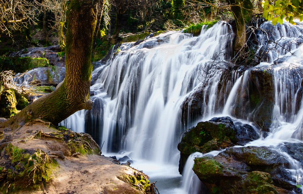
I've then shown a little detour on the map to the right to Ain Vittel (ain is spring, Vittel is one of the mineral waters of Morocco). On this detour you descend through a water meadow which is a popular picnic spot for locals, then end up at a (normally) impressive little waterfall.
Regaining the road you will pass the lion of Ifrane on the right (carved from a limestone outcrop in the early 1930s), carry straight on with what is now the RR707, you might then get a glimpse the King's palaces through the trees to the left. Fork right at the next junction onto the RP7231, driving through the cedar trees. After about 5km take a small road to the left signposted Michlifen and you will start to descend into the caldera of an extinct volcano (how cool is this?) which is used as a ski resort in winter months. You ascend via a separate road passing the King's ski lodge on the way.
As you approach the main RN13 you will probably make out other ski runs on the side of Jebel Hebri to your left, this is another volcano. Turn right (north) onto the main road and after about 4km you will reach a crossroads with souvenir huts where you are more or less guaranteed to see the macaca sylvanus monkeys (aka Barbary apes).
From the 'monkey crossroads' take the P7217 opposite the sales huts, this is a lovely quiet and relaxing drive through the cedar forest. It's very much a volcanic zone and you will see many volcanic vents that have plugged and filled with water (aguelmam).
When you reach the junction with the P7311 you could turn right/north for another coffee in Ain Leuh. Ain means spring, leuh is wood, and the 'spring of wood' name refers to the huge quantity of high quality cedar in the area. Otherwise turn left/south and after a while you will reach source of the Oum er Rbia (mother of springtime) river. Most of Morocco's rivers rise in the Middle Atlas which is known as the 'Tower of Water' and the Oum er Rbia is Morocco's longest river.
You need to park and walk gently uphill for about ten minutes until you see the river emerging, fully formed, from the rocks.
There will undoubtedly be a chance for more refreshments here, but probably steeper prices.
Regaining the P7311 route continue south with an optional detour to Aguelmame Azigza that in the summer months is a popular wild camping area for the locals and visitors alike. The video below starts at Azigza, then shows the drive back to Oum er Rbia.
Continue south to the junction with the P7306 where you turn right/west. You are still in the beautiful cedar forest but as you descend towards Khenifra the cedars give way to the evergreen holm oaks that are found at lower altitudes. I have waypointed the Atlas Zayane hotel which is an adequate but rather modern soul-less place, so if anyone finds somewhere nicer to stay I'd love to know.
Zayane is the name of one of the Amzigh tribes (the King's mother is Zayane). In 1914 the Zayane confederation won a large battle at Hebri, south of the town, against the French who lost 600 troops, more info at https://en.wikipedia.org/wiki/Zaian_War
---------- BHALIL CAVE HOUSES ----------
Beginning of day 1: Bhalil and its cave houses, take a look at this video,
We have a cave house in the Altiplano de Granada in Spain and I can attest to the temperatures quoted—never below 14ºC in winter, even when it's -5ºC outside, and never above 22ºC in summer, when it can be 42ºC outside.
This is a two day route plan through the Middle Atlas that on the first day incorporates lakes, karst scenery, 'little Switzerland', volcanos, wild monkeys, cedar forest and a massive river formation, finishing at Khenifra. The altitude varies between the 400m of Fez reaching 1750m at Ifrane and ending at 1000m in Khenifra. Despite being a route through the mountains the Middle Atlas is very much a plateau highland with no steep ascents and few dropoffs. The first day route map is at https://tinyurl.com/fez-ma-khenifra
---------- DAY 1 ----------
Leave Fez on the RN4, there are some cave houses that you *could* visit in Bhalil but they are not easy to find as most have house-like outbuilds at the front. But see note at the end of this post.
Sefrou is the cherry capital of Morocco and has a medina with crenulated walls, good place for your first coffee stop. As you climb slightly from Sefrou towards Annoceur you might spot huge kilns on the right of the road which is where the local limestone is 'cooked' with the local cedar wood to make quicklime that it used for building cement. Quicklime was at one time used for theatre stage lighting, hence 'in the limelight' expression.
Past Annoceur take a right onto the RP5106 through an area of orchards with nets against the frost. Take the right fork at the next two junctions heading for Dayet Aoua (dayat is a seasonal lake, which might be full or empty). Pass by the left side of the lake, then when you reach the main RN8 road turn left for Ifrane (pronounced ee'fran), crossing a bleak karst limestone plateau.
You pass the beautiful university of Al Akhawayn as you enter Ifrane, lessons here are given in English and there are many foreign students as well as the children of affluent Moroccans.
Ifrane was built in the 1920s during the French protectorate very much in the model of the British hill stations of India, to give families somewhere to retreat to in the melting pot of summer. Ifrane can get heavy snow in the winter and the houses have steep roofs in the style of the French Vosges mountains which is why Ifrane gets referred to as 'little Switzerland'.
I've then shown a little detour on the map to the right to Ain Vittel (ain is spring, Vittel is one of the mineral waters of Morocco). On this detour you descend through a water meadow which is a popular picnic spot for locals, then end up at a (normally) impressive little waterfall.
Regaining the road you will pass the lion of Ifrane on the right (carved from a limestone outcrop in the early 1930s), carry straight on with what is now the RR707, you might then get a glimpse the King's palaces through the trees to the left. Fork right at the next junction onto the RP7231, driving through the cedar trees. After about 5km take a small road to the left signposted Michlifen and you will start to descend into the caldera of an extinct volcano (how cool is this?) which is used as a ski resort in winter months. You ascend via a separate road passing the King's ski lodge on the way.
As you approach the main RN13 you will probably make out other ski runs on the side of Jebel Hebri to your left, this is another volcano. Turn right (north) onto the main road and after about 4km you will reach a crossroads with souvenir huts where you are more or less guaranteed to see the macaca sylvanus monkeys (aka Barbary apes).
From the 'monkey crossroads' take the P7217 opposite the sales huts, this is a lovely quiet and relaxing drive through the cedar forest. It's very much a volcanic zone and you will see many volcanic vents that have plugged and filled with water (aguelmam).
When you reach the junction with the P7311 you could turn right/north for another coffee in Ain Leuh. Ain means spring, leuh is wood, and the 'spring of wood' name refers to the huge quantity of high quality cedar in the area. Otherwise turn left/south and after a while you will reach source of the Oum er Rbia (mother of springtime) river. Most of Morocco's rivers rise in the Middle Atlas which is known as the 'Tower of Water' and the Oum er Rbia is Morocco's longest river.
You need to park and walk gently uphill for about ten minutes until you see the river emerging, fully formed, from the rocks.
There will undoubtedly be a chance for more refreshments here, but probably steeper prices.
Regaining the P7311 route continue south with an optional detour to Aguelmame Azigza that in the summer months is a popular wild camping area for the locals and visitors alike. The video below starts at Azigza, then shows the drive back to Oum er Rbia.
Continue south to the junction with the P7306 where you turn right/west. You are still in the beautiful cedar forest but as you descend towards Khenifra the cedars give way to the evergreen holm oaks that are found at lower altitudes. I have waypointed the Atlas Zayane hotel which is an adequate but rather modern soul-less place, so if anyone finds somewhere nicer to stay I'd love to know.
Zayane is the name of one of the Amzigh tribes (the King's mother is Zayane). In 1914 the Zayane confederation won a large battle at Hebri, south of the town, against the French who lost 600 troops, more info at https://en.wikipedia.org/wiki/Zaian_War
---------- BHALIL CAVE HOUSES ----------
Beginning of day 1: Bhalil and its cave houses, take a look at this video,
We have a cave house in the Altiplano de Granada in Spain and I can attest to the temperatures quoted—never below 14ºC in winter, even when it's -5ºC outside, and never above 22ºC in summer, when it can be 42ºC outside.
